
Typhoon Dolphin strengthens as Thailand faces heavy rain



Dolphin is forecast to intensify south of Japan, while Thailand’s heavy rain through August 1 is being driven by monsoon conditions.
Typhoon Dolphin is forecast to intensify rapidly over the Pacific Ocean and reach the highest level on a five-point scale while remaining south of Japan, although it is not expected to affect Thailand directly.
Chawalit Chanthararat, a director and water expert at TEAM GROUP, identified Dolphin as the 13th storm of 2026. Its name was contributed by Hong Kong and means “dolphin”.
The storm initially reached level 2 on the five-level scale while moving northwest. It was forecast to strengthen to level 4 on Wednesday (July 29) and reach level 5 on Thursday (July 30).
Projected route towards Japan and China
Chawalit’s projection indicated that Dolphin could make landfall in Japan on August 7, bringing very heavy rain to Kumamoto Prefecture, Fukuoka and surrounding areas.
The storm was then forecast to make landfall in Jiangsu province, north of Shanghai, on August 9 before continuing towards Henan province on August 11, where it could cause very heavy rain and subsequently dissipate.
The later dates extend beyond the shorter-range official forecast period available at the time, meaning the projected route, intensity and possible landfalls remain subject to change.
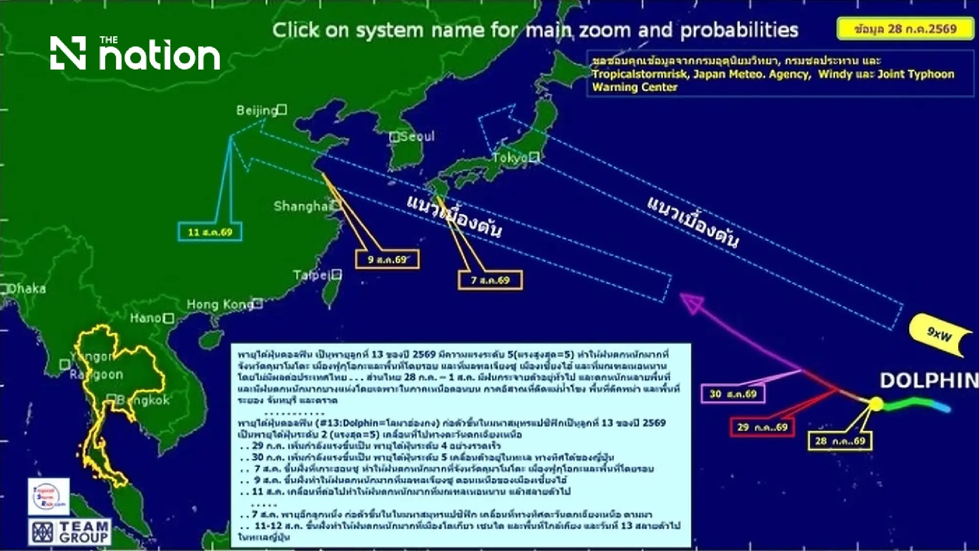
Chawalit also called for close monitoring of another storm that could form over the Pacific Ocean on August 7 and move northwest.
The second system was projected to make landfall on August 11 or 12, bringing very heavy rain to Tokyo, Sendai and surrounding areas before dissipating over the Sea of Japan on August 13. The projection remains preliminary.
Thailand rain linked to monsoon conditions
Despite Dolphin remaining away from the country, widespread rain is forecast across Thailand from July 28 to August 1, with heavy rain in many areas and isolated very heavy downpours.
Chawalit identified the upper North, northeastern provinces along the Mekong River, areas bordering Myanmar, and the eastern provinces of Rayong, Chanthaburi and Trat as locations requiring particular attention.
The Thai Meteorological Department attributed Thailand’s rainfall to a monsoon trough extending across the upper North and Northeast, together with a rather strong southwesterly monsoon over the Andaman Sea, Thailand and the Gulf of Thailand.
The conditions are therefore not a direct effect of Typhoon Dolphin.
Flood risks and rough seas
Heavy and accumulated rainfall could trigger flash floods, run-off, landslides and overflowing waterways, particularly in low-lying areas and on foothill slopes near watercourses.
Waves in the upper Andaman Sea are forecast to reach 2–3 metres, rising above three metres during thunderstorms.
The lower Andaman Sea and upper Gulf of Thailand are expected to have waves of about two metres, rising above two metres in stormy conditions.
Mariners should avoid thunderstorms, while small boats in the upper Andaman Sea have been advised to remain ashore during hazardous conditions.
