
Upper Thailand to cool as parts of the South face heavy to very heavy rain
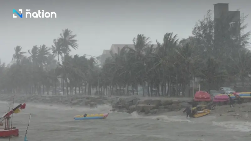


Small boats in the lower Gulf of Thailand should stay in port for two days from Saturday (November 21, 2026), with waves over 3 metres in thunderstorms.
- A high-pressure system is causing temperatures to drop by 1-3°C and winds to strengthen across upper Thailand, particularly on November 21-22.
- A strengthening northeast monsoon is bringing heavy to very heavy rain to parts of the South, with thunderstorms expected to affect 60-70% of the area on November 21-22.
- Authorities have issued a weather advisory for the South, warning residents of potential flash floods, mudslides, and overflowing rivers as a result of the intense rainfall.
- The monsoon will also create rough sea conditions in the lower Gulf of Thailand, with waves reaching 2-3 metres, and mariners are advised to navigate with caution.
The Thai Meteorological Department forecasts falling temperatures and strong winds across upper Thailand on November 21–22, while heavy to very heavy rain continues in parts of the South.
A moderate to fairly strong high-pressure system, or cold air mass, covers upper Thailand.
The north-east monsoon is strengthening over the Gulf of Thailand, the South and the Andaman Sea.
Wind and sea conditions in the lower Gulf will be fairly rough, with waves of 2–3 metres.
The high-pressure system is expected to weaken on November 23–24, while the monsoon is already weakening.
Temperatures will rise in upper Thailand, although mornings will remain cool and foggy.
Rain will ease in the South, but some areas will still see heavy falls.
A fresh, moderate high-pressure system from China will extend over upper Thailand from November 25 to 27, bringing another fall in temperatures and strong winds.
The monsoon will strengthen again, with isolated thunderstorms in the South.
Waves in the lower Gulf will be around 2 metres high from November 23 to 27, rising above 2 metres in thunderstorms.
Weather advisory for November 21–22
People in the South should be alert to flash floods, torrents of water rushing down hillsides, rivers overflowing their banks and mudslides. Foothill slopes near waterways and low-lying areas are particularly at risk from heavy to very heavy rain and the cumulative effects of rainfall.
Mariners in the Gulf of Thailand and the Andaman Sea should check their routes, navigate with caution and avoid areas with thunderstorms throughout the period.
Regional forecast for November 21–27
Mornings will be cool throughout the period in the North, North-East, Central region and East. Mountaintops in the North and North-East will be cool to cold.
North
- Temperatures will fall by 1–2°C from November 21 to 23. Lows will be 18–24°C and highs 27–34°C, with mountaintop lows of 8–14°C.
- Thunderstorms are forecast in the northern part of the region from November 24 to 27, with coverage of 10–30%. North-easterly winds of 10–20 km/h are expected. Lows will be 17–23°C and highs 26–33°C, with mountaintop lows of 7–13°C.
North-East
- Strong north-easterly winds of 15–35 km/h are forecast on November 21–22 as temperatures fall by 1–3°C. Lows will be 17–23°C and highs 27–33°C, with mountaintop lows of 10–15°C.
- Morning fog is forecast on November 23–24, with temperatures rising by 2–4°C and north-easterly winds of 10–20 km/h. Lows will be 19–24°C and highs 30–35°C, with mountaintop lows of 12–17°C.
- Strong north-easterly winds of 15–35 km/h will return from November 25 to 27 as temperatures fall by 2–4°C. Lows will be 17–23°C and highs 28–33°C, with mountaintop lows of 10–16°C.
Central region
- Temperatures will fall slightly on November 21–22, with strong north-easterly winds of 10–30 km/h. Lows will be 20–24°C and highs 30–35°C.
- Morning fog is forecast from November 23 to 25, with temperatures rising by 1–2°C and north-easterly winds of 10–20 km/h. Lows will be 21–25°C and highs 32–36°C.
- Temperatures will fall by 1–2°C on November 26–27, with strong north-easterly winds of 10–30 km/h. Lows will be 20–24°C and highs 31–35°C.
East
- Waves will exceed 2 metres in thunderstorms throughout the period.
- Temperatures will fall slightly on November 21–22, with strong north-easterly winds of 15–35 km/h. Waves will be around 1 metre high and above 2 metres offshore. Lows will be 21–26°C and highs 32–35°C.
- Morning fog is forecast on November 23–24, with temperatures rising by 1–2°C and north-easterly winds of 15–30 km/h. Waves will be below 1 metre and around 1 metre offshore. Lows will be 22–26°C and highs 33–36°C.
- Temperatures will fall by 1–2°C from November 25 to 27, with north-easterly winds of 15–35 km/h. Waves will be around 1 metre high and 1–2 metres offshore. Lows will be 21–25°C and highs 32–35°C.
South
- Thunderstorms will affect 60–70% of the area on both coasts on November 21–22, easing to 40–60% from November 23 to 27.
East coast
- Heavy to very heavy rain is forecast in places on November 21–22, with waves above 3 metres in thunderstorms. From Surat Thani province northwards, winds will be north-easterly at 15–35 km/h, with waves of 1–2 metres. From Nakhon Si Thammarat province southwards, winds will be easterly at 20–40 km/h, with waves of 2–3 metres.
- Some areas will see heavy rain from November 23 to 27. Easterly winds of 15–35 km/h are forecast, with waves of 1–2 metres, rising above 2 metres in thunderstorms.
- Lows will be 21–26°C and highs 29–34°C.
West coast
- Waves will exceed 2 metres in thunderstorms throughout the period.
- Heavy rain is forecast in places on November 21–22, with easterly winds of 15–35 km/h. Waves will be around 1 metre high and 1–2 metres offshore.
- Easterly winds of 15–30 km/h are forecast from November 23 to 27. Waves will be below 1 metre and around 1 metre offshore.
- Lows will be 23–26°C and highs 29–35°C.
Bangkok and its vicinity
- Temperatures will fall slightly on November 21–22 and again on November 26–27, with strong north-easterly winds of 10–25 km/h. Lows will be 23–26°C and highs 32–35°C.
- Temperatures will rise by 1–2°C from November 23 to 25, with light morning mist and north-easterly winds of 10–20 km/h. Lows will be 24–26°C and highs 33–36°C.
